
Heavy precipitation fell across much of the central and eastern parts of the country, bringing improvements along the Mississippi River and Great Lakes regions. There were also isolated areas of improvement in Oregon, Idaho and Montana. Extreme drought conditions were introduced in the mountainous region along the Idaho and Montana border due to concerns about low snow amounts and possible early snowmelt. Across the country in the Southeast, areas in North Carolina and southern Florida are seeing drying conditions due to low precipitation over the past few weeks. Western and southern Texas, which largely missed this week’s precipitation, saw an expansion of abnormal dryness, moderate and severe drought conditions. Flash drought conditions are appearing in Oklahoma, and Kansas, with some spillovers in eastern Colorado and western Missouri. Weeks with little precipitation, warming temperatures, dry soils and low streamflow levels are leading to rapid degradations.

Northeast
The large precipitation events that brought heavy rain across the South and into the Northeast helped improve what little dry and drought conditions remained. In western New York, moderate drought was removed. New York and surrounding areas are also seeing good streamflows and soil moisture. Nantucket was finally relieved of the lingering moderate drought, leaving abnormally dry conditions.
Southeast
There was more precipitation this week clearing up lingering abnormal dryness along the Gulf Coast. Eastern North Carolina and southern Florida missed out on this week's round of precipitation, adding to the lack of precipitation for the past 14 to 30 days, which saw the introduction and expansion of abnormal dryness.
South
Heavy precipitation fell across eastern Texas, Louisiana, southern Arkansas and west-central Mississippi. This brought improvements in northeast Mississippi, leaving the state drought-free with only some lingering abnormally dry conditions. While less precipitation fell in Tennessee, the western part of the state also saw improvements. Conversely, southern Texas and Oklahoma are seeing conditions worsen as conditions continue to quickly deteriorate. Conditions in Oklahoma into Kansas are seeing rapid degradation and short-term dryness indicating flash drought conditions.
Midwest
Conditions across the Midwest continued to improve, except for western Missouri and a small area in western Michigan. The central and eastern parts of the Midwest received 1 to 2.5 inches of rain, bringing improvements to Missouri, Illinois, Indiana and the Kentucky border. Eastern Iowa also saw slight improvements due to improved conditions over the past 30 to 90 days, though longer-term conditions of 6 months or more are still showing dryness. Western Missouri missed out on the precipitation, further degrading already dry conditions similar to Kansas and Oklahoma.
High Plains
The southern High Plains are in the grips of rapidly drying conditions, leading to degradations across Kansas, with conditions bleeding into eastern Colorado and southern Nebraska. Western Kansas has not seen precipitation in over two weeks, providing no relief to the rapidly drying soils and low streamflows. Conditions in Kansas into Oklahoma are seeing rapid deterioration and short-term dryness indicating flash drought conditions.

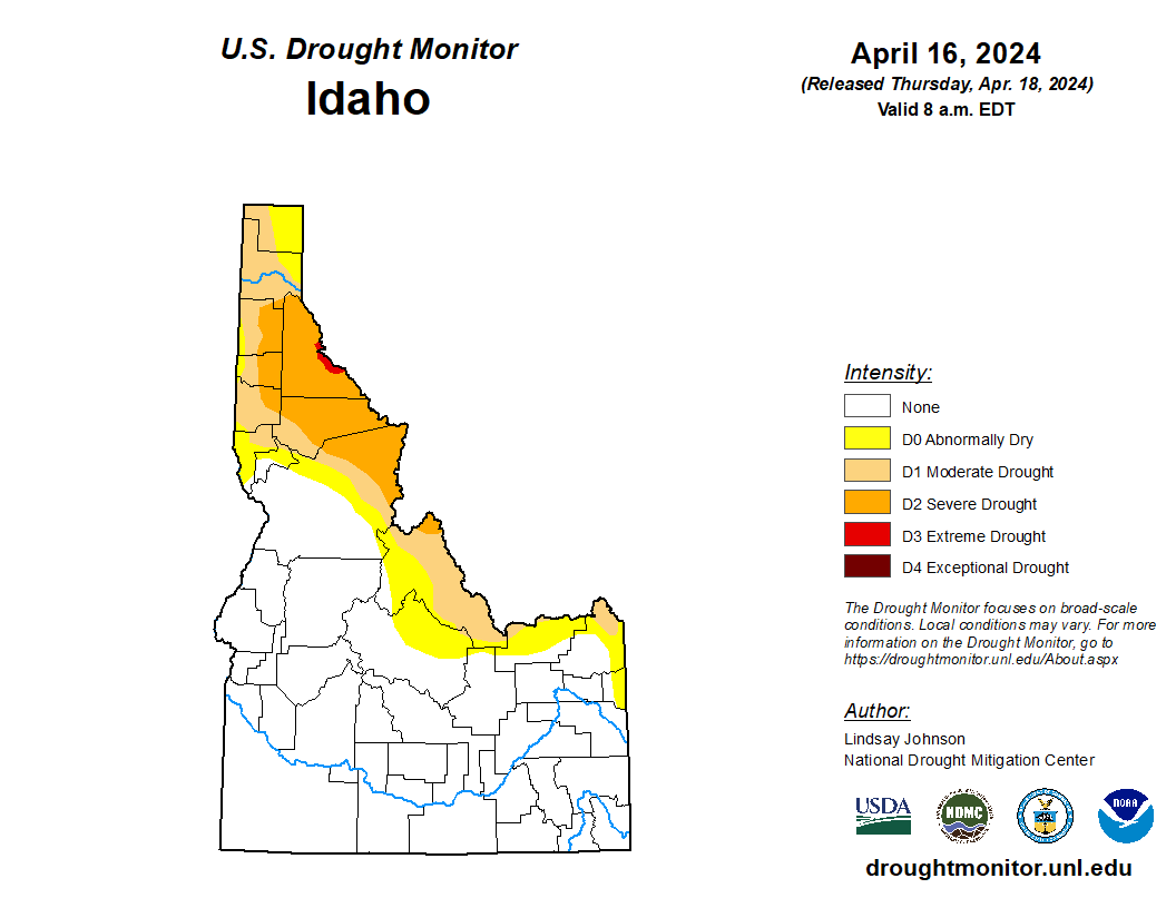
West
The West saw conditions remain mostly the same, with areas in the Northwest seeing some improvements. Regions along the Pacific coast received some precipitation but not in areas needing moisture. There was some improvement in southern Oregon where precipitation did fall. Southern Idaho also saw improvement with the precipitation and decent snowpack. Northern Idaho into Montana did see some degradation, with mountainous areas seeing snow at extremely low levels. Western Montana experienced improvements in the east-central part of the state.
Caribbean
Puerto Rico is currently experiencing a wet pattern bringing continuing improvements in the southwest and southeastern parts of the island where abnormal dryness (D0) was removed.
On St. Croix, the weekly rainfall amount ranged from 1.35 inches at VI-SC-30 (Christiansted 1.7 SW) to 3.90 inches at VI-SC-35 (Frederiksted 1.3 ENE). Intermediate values included 1.37 inches at VI-SC-10 (Christiansted 1.6 E), 2.72 inches at VI-SC-20 (Frederiksted 1.7 ESE), 1.44 inches at VI-SC-23 (Christiansted 6.5 W), 1.37 inches at VI-SC-25 (Christiansted 4.4W), 1.52 inches at VI-SC-29 (Frederiksted 2.5 NNE), and 1.83 inches at VI-SC-34 (Frederiksted 1.9NE). Due to the recent rains, the depth to water level at Adventure 28 Well (St. Croix, USVI) on April 16, 2024 was 30.42 ft below land surface decreasing from last week (30.74 ft). Thus, St. Croix remained free of drought.
On St. John, rainfall amounts reported at VI-SJ-5 (Cruz Bay 1.6 E) and VI-SJ-9 (Trunk Bay 0.2 W) were 1.27 and 0.51 inches, respectively. In addition, VI-SJ-3 (Windswept Beach) observed 0.99 inches of rain. The depth to water level at Susannaberg DPW 3 well (St. John, USVI) on April 16, 2024 was 11.86 ft below land surface., which has slightly increased this week as compared to last week (i.e., 11.67 ft). However, the yearly graph shows relatively a shallow depth resulting St. John to remain free of drought for this week.
Pacific
On St. Thomas, rainfall totals this week ranged from 0.5 inch at VI-ST-15 (Charlotte Amalie West 1.3N) to 2.02 inches at VI-ST-5 (Charlotte Amalie West 4.2 WNW). In addition, at VI-ST-13 (Charlotte Amalie 1.2 NNW), 1.66 inches of rain was reported. The depth to water level Grade School 3 well (St. Thomas, USVI) on April 16, 2024 was 10.35 ft below land surface, which is an increase in depth to water level as compared to last week (i.e., 7.03 ft). This shows the persistence of abnormally dry conditions. Thus, St. Thomas remained in D0-L (long-term abnormally dry category).
There were no changes made in Alaska this week.
Hawaii had significant rain events late last week (April 11-14). Kauai got 10 to 12 inches over Thursday evening (April 11). The second round of storms brought a further 1 to 3 inches of precipitation over most of the islands, leading to improvements on all but the Big Island.
Wet conditions prevailed across most parts of the Marshall Islands this week. Jaluit reported 4.12 inches of rain, resulting in drought-free conditions. Also, Ailinglapalap received heavy showers (5.51 inches of rain) this week, improving from moderate drought to abnormally dry conditions. Even though Majuro reported 3.54 inches of rain, the island remained in short-term extreme drought due to below-normal weekly rainfall (less than 2 inches) for the past nine weeks. This week, no rain was reported on Wotje, so the island remained in short- and long-term extreme drought conditions. Similarly, no rain was reported on Kwajalein, with 2 days missing, and it remained in short-term moderate drought conditions. No depiction was made for Milli and Utirik due to missing data.
This week, the dry trade-wind pattern continued with generally spotty light showers, worsening drought conditions. Only a few locally moderate to heavy showers were observed across western Micronesia south of 10°N latitude, as the current El Niño drought holds its grip across the islands. On Ulithi, 0.01 inches of rain with two days missing was reported this week. Because Ulithi received less than 2 inches of rain for consecutive eleven weeks, the island deteriorated to short-term exceptional drought. Similarly, Yap received only 0.01 inches of rain (with one day missing) to remain in short-term exceptional drought.
In contrast, wet conditions were observed on Lukunoch, Nukuoro, Pohnpei and Pingelap, reporting 4.15, 3.93, 3.39 and 2.23 inches of rainfall this week, respectively. These locations remained free of drought. Kapingamarangi and Kosrae reported 3.47 and 1.90 inches of rain, respectively, to remain free of drought. On Chuuk, 5.38 inches of rain was observed this week, allowing the island to improve from moderate drought to abnormally dry conditions.
Normal conditions prevailed across American Samoa. Pago Pago reported 2.54 inches of rain this week, remaining free of drought. In addition, Siufaga Ridge and Toa Ridge observed 3.18 and 2.28 inches of rain this week, respectively.
Heavy scattered showers were reported on Palau this week. Palau IAP (Airai) reported 2.99 inches of rain this week. Koror COOP station also reported 1.74 inches of rain. However, due to drier-than-normal conditions in the past few weeks, the island remained in short-term abnormally dry conditions.
This week, dry conditions continued across the Mariana Islands. On Saipan, only 0.80 inches of rain was observed this week. In addition, Saipan (ASOS) received only 0.48 inches of rain. Thus, Saipan deteriorated to extreme drought conditions. Also, Rota received weekly totals of only 0.041 inches of rain (one day missing) to remain in short-term moderate drought. On Guam, only 0.30 inches of rain (with one day missing) was reported this week, and the island deteriorated to extreme drought conditions. Reports showed that Guam International Airport’s Keetch-Byram Drought Index (KBDI) has slightly increased to 704, which is in the high range.
Looking Ahead
Over the next 5 days (April 19-23), more heavy precipitation is expected in the Plains and Midwest. Iowa, Nebraska and South Dakota could see upwards of 2.5 inches of precipitation. Northeast Texas, southeastern Oklahoma, and western Arkansas could see 1.5 to 2 inches of precipitation. Areas of higher elevation in the Rockies of Colorado and Wyoming are also expected to see between 1-2 inches.
The National Weather Service Climate Prediction Center’s 6 to10-day outlook (Valid April 22) favors above-normal precipitation for southern parts of the U.S., particularly along the eastern Gulf Coast from Texas and Louisiana into parts of Arkansas and Oklahoma. Florida is also favoring above-normal precipitation. The Northwest and Northeast are leaning towards below-normal precipitation. From the middle of Pennsylvania northward, below-normal precipitation is likely to occur. Hawaii is also leaning towards below-normal precipitation and Alaska is leaning towards above-normal precipitation. In terms of the temperature outlook, above-normal temperatures are expected from the West into the High Plains, as well as along the Gulf Coast and Florida. Utah, Nevada, northern Arizona, northern New Mexico and western Colorado are showing a 70-80% likelihood of above-normal temperatures. Eastern Alaska is also leaning towards above-normal temperatures. The Mid-Atlantic region and the eastern Midwest are leaning toward below-normal temperatures. Hawaii and western Alaska are favoring below-normal temperatures.


.jpg)
.png)